


3,1 km | 4,3 km-effort
![Randonnée A pied Horn-Bad Meinberg - Rundwanderweg A4 [Feldrom] - Photo](https://media.geolcdn.com/t/1900/400/c3e2fda2-4a4b-4515-b251-ad31aeb36002.jpeg&format=pjpeg&maxdim=2)

Tous les sentiers balisés d’Europe GUIDE+


Application GPS de randonnée GRATUITE
 SityTrail
IGN / Instituts géographiques
SityTrail World
Le monde est à vous
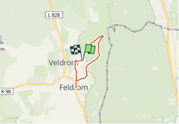
Randonnée A pied de 3,3 km à découvrir à Rhénanie-du-Nord-Westphalie, Kreis Lippe, Horn-Bad Meinberg. Cette randonnée est proposée par SityTrail - itinéraires balisés pédestres.
Symbole: weiße Schrift "A4" auf schwarzen Grund
![Randonnée A pied Horn-Bad Meinberg - Rundwanderweg A4 [Feldrom] - Photo 1](https://media.geolcdn.com/t/2048/auto/8c185d7a-d4c3-47b4-9174-d7d19c0ef50a.jpeg&format=jpg&maxdim=0 "Randonnée A pied Horn-Bad Meinberg - Rundwanderweg A4 [Feldrom] - Photo 1")
![Randonnée A pied Horn-Bad Meinberg - Rundwanderweg A4 [Feldrom] - Photo 2](https://media.geolcdn.com/t/2048/auto/8b3e6ce4-73bf-46e6-94bf-cc786bd1caec.jpeg&format=jpg&maxdim=0 "Randonnée A pied Horn-Bad Meinberg - Rundwanderweg A4 [Feldrom] - Photo 2")
![Randonnée A pied Horn-Bad Meinberg - Rundwanderweg A4 [Feldrom] - Photo 3](https://media.geolcdn.com/t/2048/auto/4c3a3672-dbbf-4a94-9d8c-60165eb46ffe.jpeg&format=jpg&maxdim=0 "Randonnée A pied Horn-Bad Meinberg - Rundwanderweg A4 [Feldrom] - Photo 3")
![Randonnée A pied Horn-Bad Meinberg - Rundwanderweg A4 [Feldrom] - Photo 4](https://media.geolcdn.com/t/2048/auto/308c6e9d-9562-4c6c-8b05-3da143c120b7.jpeg&format=jpg&maxdim=0 "Randonnée A pied Horn-Bad Meinberg - Rundwanderweg A4 [Feldrom] - Photo 4")
![Randonnée A pied Horn-Bad Meinberg - Rundwanderweg A4 [Feldrom] - Photo 5](https://media.geolcdn.com/t/2048/auto/c4b2559c-d13f-498c-8938-09f0f7b659f8.jpeg&format=jpg&maxdim=0 "Randonnée A pied Horn-Bad Meinberg - Rundwanderweg A4 [Feldrom] - Photo 5")
![Randonnée A pied Horn-Bad Meinberg - Rundwanderweg A4 [Feldrom] - Photo 6](https://media.geolcdn.com/t/2048/auto/83967b3b-7e23-4a72-9ba6-79e50f2fcf2d.jpeg&format=jpg&maxdim=0 "Randonnée A pied Horn-Bad Meinberg - Rundwanderweg A4 [Feldrom] - Photo 6")
![Randonnée A pied Horn-Bad Meinberg - Rundwanderweg A4 [Feldrom] - Photo 7](https://media.geolcdn.com/t/2048/auto/3a98f1eb-997f-4f48-a14a-a7d445dae24e.jpeg&format=jpg&maxdim=0 "Randonnée A pied Horn-Bad Meinberg - Rundwanderweg A4 [Feldrom] - Photo 7")
![Randonnée A pied Horn-Bad Meinberg - Rundwanderweg A4 [Feldrom] - Photo 8](https://media.geolcdn.com/t/2048/auto/69674eaa-50ba-4d94-ac0e-bc696ae8c00c.jpeg&format=jpg&maxdim=0 "Randonnée A pied Horn-Bad Meinberg - Rundwanderweg A4 [Feldrom] - Photo 8")
![Randonnée A pied Horn-Bad Meinberg - Rundwanderweg A4 [Feldrom] - Photo 9](https://media.geolcdn.com/t/2048/auto/15611719-8337-42ec-ae63-2fa14ec04562.jpeg&format=jpg&maxdim=0 "Randonnée A pied Horn-Bad Meinberg - Rundwanderweg A4 [Feldrom] - Photo 9")
![Randonnée A pied Horn-Bad Meinberg - Rundwanderweg A4 [Feldrom] - Photo 10](https://media.geolcdn.com/t/2048/auto/c3e2fda2-4a4b-4515-b251-ad31aeb36002.jpeg&format=jpg&maxdim=0 "Randonnée A pied Horn-Bad Meinberg - Rundwanderweg A4 [Feldrom] - Photo 10")
A pied
A pied
A pied
A pied
A pied
A pied
![Randonnée A pied Steinheim - Rundwanderweg A1 [Grevenhagen] - Photo](https://media.geolcdn.com/t/375/260/202ac17e-dbff-44d1-b3d9-93eb341f466c.jpeg&format=jpg&maxdim=2)
A pied
![Randonnée A pied Horn-Bad Meinberg - Rundwanderweg A1 [Holzhausen-Externsteine] - Photo](https://media.geolcdn.com/t/375/260/917c6440-8043-45d4-9c08-101f3367a522.jpeg&format=jpg&maxdim=2)
A pied
![Randonnée A pied Schlangen - Rundwanderweg 34 [Barnacken] - Photo](https://media.geolcdn.com/t/375/260/83e8c965-88dc-4fa7-9331-4da86113c518.jpeg&format=jpg&maxdim=2)
A pied